Meghalaya, India
Cherrapunji
One of the wettest places on Earth — Nohkalikai Falls (India's tallest), living root bridges and endless monsoon cascades.
The Seven Sisters Waterfall in Cherrapunji is currently active and flowing strongly. Recent rainfall totals about 91 mm in the past week, keeping the falls impressive. If you visit this week, expect wet conditions and slippery paths, so plan accordingly.
Confidence: 100%
Weather
7-day forecast☀️ Sun & Daylight
today🌅 Sunrise
04:41 AM
🌇 Sunset
06:16 PM
📸 Golden hour
05:46 PM
⏱️ Daylight
13h 35m
Dawn 04:17 AM · Dusk 06:40 PM · Critical for ADV rides — avoid mountain roads after dusk.

🧭 Travel guide — Cherrapunji
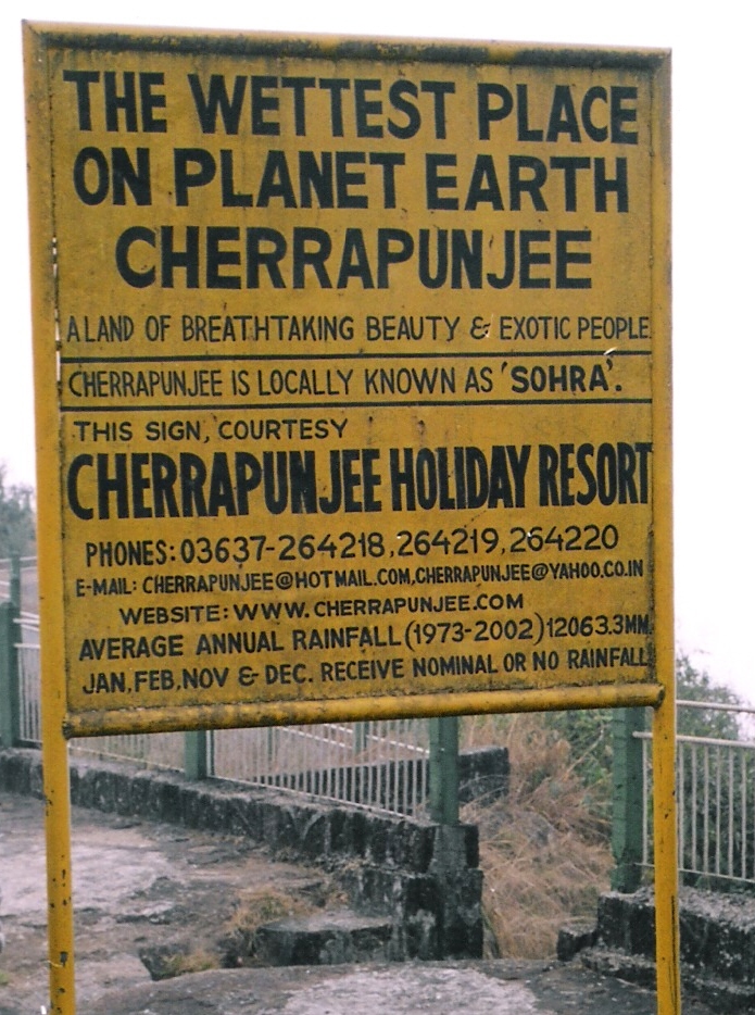
Cherrapunji (also spelled as Cherrapunjee and Charrapunji, but almost always called Sohra by locals), is a town in East Khasi Hills district in the Indian state of Meghalaya. The town receives 11,777 mm (463.7 in) of rain per year, but that is less than half as much rain as in the days a few decades ago when it was still known as the wettest place on Earth. The winter (non-monsoon) season can be quite dry.
Read full article →📖 About — Cherrapunji
Cherrapunji ( ), also known as Sohra, is a sub-divisional town (Proposed District) in the East Khasi Hills district in the Indian state of Meghalaya. It was the traditional capital of ka hima Sohra (Khasi tribal kingdom). Sohra has often been credited as being the wettest place on Earth, but currently, nearby Mawsynram holds that distinction. Sohra still holds the all-time record for the most rainfall in a calendar month and in a year, however. It received 9,300 millimetres (370 in; 30.5 ft) in July 1861 and 26,461 millimetres (1,041.8 in; 86.814 ft) between 1 August 1860 and 31 July 1861.
Read full article →📷 Photos nearby(12)
.jpg)


.jpg)
.jpg)


.jpg)


Click any photo for full size and licensing info.
Recent news
- Air quality in Cherrapunji - IQAir
IQAir · 24 d ago
- Cherrapunji Records Its Third-Highest Historic Downpour With 972 mm of Rain in a Single Day - Borok Times
Borok Times · 24 d ago
- India Travel Craze Grows Stronger As Goa, Munnar, Coorg, Valley Of Flowers And Cherrapunji Become Powerful Rain-Season Destinations For Nature Lovers And Global Travellers - Travel And Tour World
Travel And Tour World · 1 mo ago
- Monsoon alert for travellers : Heading to hill stations ? Check IMD rain warning for these states
economictimes.indiatimes.com · 1 mo ago
- Cherrapunji’s misty cliffs and green valleys in Meghalaya - MSN
MSN · 1 mo ago
- Cherrapunji’s misty cliffs and green valleys in Meghalaya - MSN
MSN · 1 mo ago
- Meghalaya proposes railway line between Shillong and Cherrapunji - The News Mill
The News Mill · 2 mo ago
- Plea against Sonam bail : Meghalaya HC to hear case on June 3 | Guwahati News
timesofindia.indiatimes.com · 2 mo ago
Recent videos

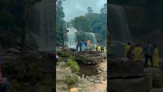
Seven Sisters Waterfall || Meghalaya || #meghalaya #cherrapunji #waterfall
The Taylor vlog’s · 18 d ago
WATERFALL #lyngksiarfalls meghalaya Cherrapunji(sohra)
NISHAN YT · 18 d ago

kaise karte hai pilots go around #travel #cherrapunji #simplytravel #meghalaya
Safar Unlimited · 18 d ago

Blue Logon Meghalaya | Best Swimming Pool In Cherrapunji 2026
Shillong Cab Rental & Travel Vlog · 18 d ago
Literally touching clouds in Cherrapunji Meghalaya
Aarush Pratap Singh · 18 d ago

Delhi to Meghalaya | Cherrapunji- World's Wettest Place | 5100 KM Northeast India Road Trip| Vlog 21
TheVipinWay · 18 d ago
💬 Community mentions
Places to visit in Cherrapunji
8 places to explore nearby


Nohsngithiang Falls
Nohsngithiang Falls is a seven-segmented waterfall located 1 kilometre (0.62 mi) south of Mawsmai village in East Khasi Hills district in the Indian state of Meghalaya. The water falls from a height of 315 metres (1,033 ft) and has an average width of 70 metres (230 ft). making it one of the tallest waterfalls in India.

Wah Kaba Falls
Wah Kaba Falls is a waterfall located near Cherrapunji in Meghalaya, in the north eastern India. The waterfall descends from a steep rockface and drops approximately 170–190 metres into a gorge. There is a local legend that two fairies live at the falls. The falls can be seen on the way to Cherrapunji from Shillong.

Nohkalikai Falls
Nohkalikai Falls, sometimes Ka Likai, is the tallest plunge waterfall in India. The 340 metres (1,115 ft) waterfall is located in the Indian state of Meghalaya, near Cherapunji, one of the wettest places on Earth. Nohkalikai Falls are fed by the rainwater collected on the summit of a comparatively small plateau and decrease in power during the dry season, from December to February. Below the falls

Kynrem Falls
The Kynrem Falls is located 12 kilometres (7.5 mi) from Cherrapunji in East Khasi Hills district in the Indian state of Meghalaya. It is situated inside the Thangkharang Park. It is the 7th highest waterfalls in India. The Kynrem Falls is a three-tiered waterfall, with water falling from a height of 305 metres (1,001 ft). The fall spreads out in two different streams or rivulets with each of them


You might also like
Trip Stories
0 storiesNo trip stories yet for this destination.
Be the first to share your experience!